.png)
Project Overview
Appointed to manage a tailings storage facility (TSF) embankment raise at a large copper mine, WSP needed a fast way to monitor construction progress. Construction was about to begin and with tight deadlines in place they needed independent construction surveys from day one. Their client’s survey team on site didn’t have capacity to take on the work, so they needed another option.
So, they deployed an autonomous drone system to deliver monthly reporting on placed volumes and conformance to design. Once in place, they quickly realised it could also provide valuable daily imagery and measurements that neither WSP nor the site operator had access to before. The site now uses the same drone system for daily tailings surveys and reporting while WSP, as Engineer of Record (EoR) for the TSF, has instant remote access to all of the data and imagery they need.
The challenge: Independent assurance under pressure
Tailings construction demands tight control over sequencing, materials, and documentation. WSP wanted reliable independent evidence, captured regularly, to verify progress and support their quality assurance process.
Brad Tiver, Principal Tailings Engineer at WSP and EoR for the TSF, explains: “During construction, we knew we’d need a steady flow of reliable data to make sure the project was on track.”
Ideally, site surveyors could handle this monitoring. But with their survey capacity already spoken for, WSP needed another way to get reliable data without slowing work on the wall raise project.
One alternative was to engage a contractor for ground-based surveys, but that would be slow and could interrupt construction so wasn’t seen as a good option.
%20(1440%20x%20720%20px)%20(800%20x%20600%20px).png)
Their solution: autonomous survey drones
WSP reached out to RocketDNA for advice on how to set up independent monitoring quickly.
We recommended an on-site autonomous drone system as the best option. It could be mobilised fast because of our existing CASA approvals, so we could handle the full data workflow, including data capture, processing, integration, and reporting.
This would give WSP finished geospatial outputs they could use immediately, rather than raw imagery they would have to handle and process themselves.
Implementation: fast and simple
We deployed the system within weeks and began scheduled construction surveys once per month, delivering processed reports WSP could use directly for QA/QC. All data captured was deposited in SiteTube, a shared web platform where WSP and the site operator could access the survey data and imagery.
Easy shared access to data changed the pace of decision-making. As Tiver put it:
“Having me and my team being able to look at whatever I need whenever I need, that’s the powerful part of it.”
From day one, WSP’s office team and onsite personnel worked from the same record, without needing to chase ad-hoc images and worry about file sharing and drive access.
.png)
Expansion: from construction assurance to daily operational visibility
Once the system was in place and they saw the value of the construction surveys, the mine operator quickly realised it could also solve another problem for them.
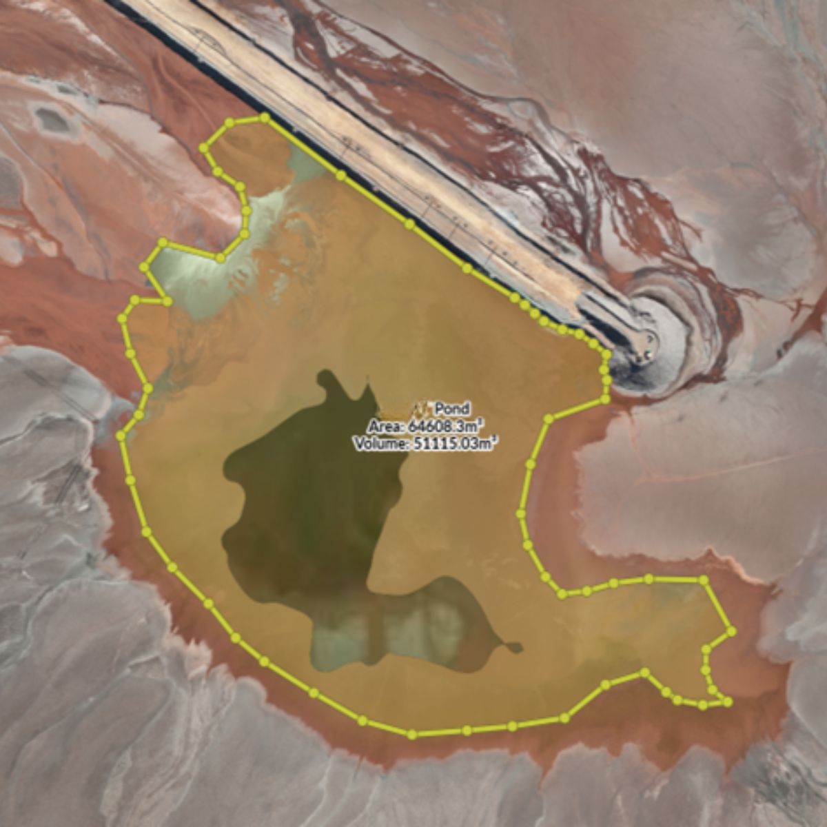
During a wall raise, pipework and spigots are disconnected and repositioned. That makes pond levels and water distribution harder to control, adding operational complexity on top of construction.
To manage this balancing act, they expanded the drone program to include:
- Daily pond measurements to guide pumping and deposition decisions.
- Weekly freeboard surveys of the wall perimeter.
- Twice-daily fixed-point 360 degree panoramas to build a consistent record and track any surface changes, movement, or erosion
With these additions, site teams can now act on same-day measurements, and WSP has a continuous visual record to oversee conditions remotely, without waiting on ad-hoc updates. Shared data access with SiteTube makes it easy for anyone involved in managing the TSF to find the imagery they need immediately.
As EoR for the facility, data access and accuracy is particularly important for Brad. He says “As Engineer of Record, the responsibility is on me. I need the right data available so I can decipher it and make sense of it.”
Results: accurate, useful data for peace of mind
What began as an urgent need for independent construction surveys during a wall raise became something much more valuable. With autonomous drones, WSP secured the data required to report on project progress, and also gave the mine operator daily visibility over tailings management.
Now, both on-site staff and WSP’s remote team can see conditions as they are today, whenever they need to.
Location

Contact RocketDNA Today
Interested in finding out more about how our drone data solutions can assist you with your data need?
Complete the contact form to get started and find out more.